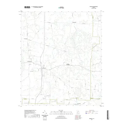
2020 Map of Damascus
USGS Topo · Published 2020About this map
Damascus serves as the central hub of this South Georgia landscape, where agricultural tradition meets the wetland systems of the Coastal Plain. The map reveals a high concentration of burial sites and family landmarks, including Damascus Cem, Billings Cem, and Pullen Cem, which provide essential clues for genealogical research in Early County. Settlement patterns follow established routes like Five Bridges Rd and Old Damascus Rd, connecting smaller communities like Douglasville and Douglass Crossroads. The terrain is defined by the drainage networks of Big Cypress Cr and Alligator Cr, which snake through the eastern portion of the quadrangle. In the south, the village of Macedonia sits near the Baker County line, while local identifiers like Long Br and Big Drain mark the low-lying hydrology characteristic of the region.
Find a feature on this map
76 named features on this map. Tap any name to fly to it.
Don’t see what you’re looking for? This feature index may not catch every label — zoom into the map to look around manually.
Map Details
Editions of this 2020 Damascus Map
This is the sole edition of this map. No revisions or reprints were ever made.
Other maps of this area

1953 · Dothan
USGS Topo · 1:250,000

1954 · Dothan
USGS Topo · 1:250,000

1955 · Dothan
USGS Topo · 1:250,000

1973 · Bancroft
USGS Topo · 1:24,000

1973 · Hentown
USGS Topo · 1:24,000

1974 · Donalsonville NE
USGS Topo · 1:24,000

1974 · Damascus
USGS Topo · 1:24,000

1974 · Arlington
USGS Topo · 1:24,000

1974 · Cooktown
USGS Topo · 1:24,000
1974 · Colquitt
USGS Topo · 1:24,000