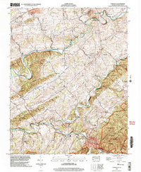
2002 Map of Damascus
USGS Topo · Published 2004About this map
Damascus sits at the confluence of several mountain waterways where the South Fork Holston River meets Laurel Creek. This region of Washington County is defined by the tight ridges of Widener Valley and Rhea Valley, which forced early settlement and industry into narrow corridors along the rivers. The map documents a surviving network of water-powered heritage, including Mock Mill, De Busk Mill, and Vails Mill, reflecting the long-standing reliance on local milling in these Appalachian valleys. The landscape is also marked by historic transport and crossings like Drowning Ford and Mast Bridge. Higher elevations are protected within the Jefferson National Forest, where the Appalachian Trail and Iron Mountain Trail wind through the Jefferson Mountains, passing peaks such as The Cuckoo.
Find a feature on this map
58 named features on this map. Tap any name to fly to it.
Don’t see what you’re looking for? This feature index may not catch every label — zoom into the map to look around manually.
Map Details
Editions of this 2002 Damascus Map
This is the sole edition of this map. No revisions or reprints were ever made.
Other maps of this area

1891 · Abingdon
USGS Topo · 1:125,000

1894 · Abingdon
USGS Topo · 1:125,000

1909 · Abingdon
USGS Topo · 1:96,000

1911 · Abingdon
USGS Topo · 1:125,000

1935 · Konnarock
USGS Topo · 1:24,000

1935 · Chilhowie
USGS Topo · 1:24,000
1935 · Abingdon
USGS Topo · 1:24,000

1935 · Grayson
USGS Topo · 1:24,000

1935 · Mount Rogers
USGS Topo · 1:48,000
1935 · Laurel Bloomery
USGS Topo · 1:24,000