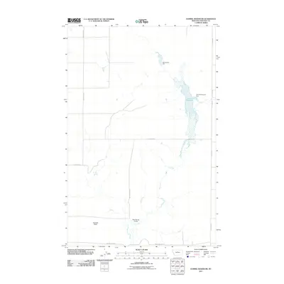
2011 Map of Dammel Reservoir
USGS Topo · Published 2011About this map
Dammel Reservoir and its associated Dammel Reservoir Dam anchor this segment of the Montana plains in Chouteau County. The landscape is defined by the ephemeral drainage of Flat Creek, which feeds into the reservoir from the south, passing through the distinctive Mud Spring Coulee. Further north, Manchurians Dam represents another significant water management feature in this arid environment. The terrain is marked by notable elevations such as Haystack Butte and the smaller Mud Springs to the west. This 2011 survey illustrates a sparsely populated agricultural and ranching landscape, organized by a grid of named rural roads including Dorn Coulee Rd and Prairie Dog Jim Rd, which provide access to the remote coulees and buttes of this northern territory.
Find a feature on this map
12 named features on this map. Tap any name to fly to it.
Don’t see what you’re looking for? This feature index may not catch every label — zoom into the map to look around manually.
Map Details
Editions of this 2011 Dammel Reservoir Map
This is the sole edition of this map. No revisions or reprints were ever made.
Other maps of this area

1890 · Fort Benton
USGS Topo · 1:250,000

1892 · Fort Benton
USGS Topo · 1:250,000

1897 · Fort Benton
USGS Topo · 1:250,000

1953 · Eagle Buttes
USGS Topo · 1:24,000

1954 · Great Falls
USGS Topo · 1:250,000

1957 · Great Falls
USGS Topo · 1:250,000
1972 · Eagle Buttes SW
USGS Topo · 1:24,000

1972 · Square Butte SE
USGS Topo · 1:24,000

1972 · Square Butte
USGS Topo · 1:24,000
1972 · Stranahan SE
USGS Topo · 1:24,000