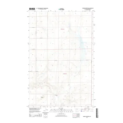
2014 Map of Dammel Reservoir
USGS Topo · Published 2014About this map
Haystack Butte rises as a prominent landmark in this section of Chouteau County, anchoring a landscape defined by intermittent water sources and wide-open rangeland. The presence of Dammel Reservoir in the northeast provides a localized water catchment, while the winding path of Flat Creek and the headwaters at Mud Springs dictate the natural drainage patterns of the area. This 2014 survey reveals a sparse network of county roads and trails, such as Cow Trl and Dorn Coulee Rd, which primarily facilitate access between scattered agricultural parcels. The terrain is marked by significant geographic depressions, notably Mud Spring Coulee, which illustrate the erosional history of the central Montana plains. The arrangement of section lines and range boundaries like t23n r12e reflects the enduring legacy of the Public Land Survey System in organizing this rural territory.
Find a feature on this map
16 named features on this map. Tap any name to fly to it.
Don’t see what you’re looking for? This feature index may not catch every label — zoom into the map to look around manually.
Map Details
Editions of this 2014 Dammel Reservoir Map
This is the sole edition of this map. No revisions or reprints were ever made.
Other maps of this area

1890 · Fort Benton
USGS Topo · 1:250,000

1892 · Fort Benton
USGS Topo · 1:250,000

1897 · Fort Benton
USGS Topo · 1:250,000

1953 · Eagle Buttes
USGS Topo · 1:24,000

1954 · Great Falls
USGS Topo · 1:250,000

1957 · Great Falls
USGS Topo · 1:250,000
1972 · Eagle Buttes SW
USGS Topo · 1:24,000

1972 · Square Butte SE
USGS Topo · 1:24,000

1972 · Square Butte
USGS Topo · 1:24,000
1972 · Stranahan SE
USGS Topo · 1:24,000