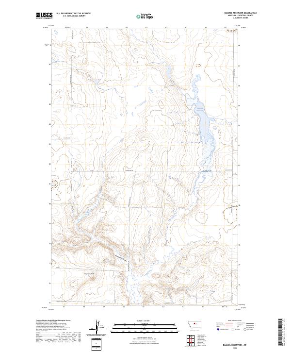
2024 Map of Dammel Reservoir
USGS Topo · Published 2024About this map
Dammel Reservoir anchors this high-plains landscape in Chouteau County, serving as a vital water source in an area defined by long coulees and ephemeral drainages. The topography is marked by significant elevation changes, most notably at Haystack Butte in the southwest and along the winding path of Mud Spring Coulee. The map reveals a highly organized township and range system, with a network of rural routes such as Sunnyside Rd and Dorn Coulee Rd following the sectional grid lines. This grid-based development suggests a landscape dedicated to large-scale ranching and dryland farming, where access is dictated by the cardinal directions of the surveyor's lines. Water features like Flat Creek and Mud Spring provide the only breaks in the geometric regularity of the land, tracing the natural contours of the Montana prairie.
Find a feature on this map
17 named features on this map. Tap any name to fly to it.
Don’t see what you’re looking for? This feature index may not catch every label — zoom into the map to look around manually.
Map Details
Editions of this 2024 Dammel Reservoir Map
This is the sole edition of this map. No revisions or reprints were ever made.
Other maps of this area

1890 · Fort Benton
USGS Topo · 1:250,000

1892 · Fort Benton
USGS Topo · 1:250,000

1897 · Fort Benton
USGS Topo · 1:250,000

1953 · Eagle Buttes
USGS Topo · 1:24,000

1954 · Great Falls
USGS Topo · 1:250,000

1957 · Great Falls
USGS Topo · 1:250,000
1972 · Eagle Buttes SW
USGS Topo · 1:24,000

1972 · Square Butte SE
USGS Topo · 1:24,000

1972 · Square Butte
USGS Topo · 1:24,000
1972 · Stranahan SE
USGS Topo · 1:24,000