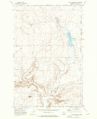
1972 Map of Dammel Reservoir
USGS Topo · Published 1976About this map
Dammel Reservoir serves as a focal point in this portion of Chouteau County, where the topography transitions from the high ground of Haystack Butte down into the drainage of Flat Creek. This 1970s landscape is defined by the practical infrastructure of dryland farming and ranching, evidenced by numerous Storage Bins and a singular Storage Bin strategically placed near the coulees. The complex erosion patterns of Mud Spring Coulee and Mud Springs illustrate the essential role of water management in this semi-arid region. These features suggest a period of agricultural adaptation, where modern storage and water impoundment were vital to the local economy and land use.
Find a feature on this map
7 named features on this map. Tap any name to fly to it.
Don’t see what you’re looking for? This feature index may not catch every label — zoom into the map to look around manually.
Map Details
Editions of this 1972 Dammel Reservoir Map
This is the sole edition of this map. No revisions or reprints were ever made.
Other maps of this area

1890 · Fort Benton
USGS Topo · 1:250,000

1892 · Fort Benton
USGS Topo · 1:250,000

1897 · Fort Benton
USGS Topo · 1:250,000

1953 · Eagle Buttes
USGS Topo · 1:24,000

1954 · Great Falls
USGS Topo · 1:250,000

1957 · Great Falls
USGS Topo · 1:250,000
1972 · Eagle Buttes SW
USGS Topo · 1:24,000

1972 · Square Butte SE
USGS Topo · 1:24,000

1972 · Square Butte
USGS Topo · 1:24,000
1972 · Stranahan SE
USGS Topo · 1:24,000