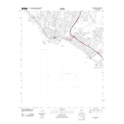
2012 Map of Dana Point
USGS Topo · Published 2012About this map
Dana Point and its sophisticated maritime infrastructure anchor this coastal survey, where the sheltered Dana Point Harbor is divided into the West Basin and East Basin. This modern shoreline development is balanced by natural coastal landmarks such as Three Arch Bay and San Juan Rocks, while the Orange County Marine Institute stands as a focal point for maritime education at Dana Cove. The inland landscape is defined by the winding course of San Juan Cr and the prominent elevations of Folsom Ridge and Coyote Bluff. To the north, residential expansion is evident in the dense street networks of Three Arch Bay and the vicinity of Cook Reservoir, while the southern reaches follow the curve of Capistrano Bight toward the San Clemente City Beach border. The presence of the Post Office in the center of Dana Point and the overlook at Ken Sampson Overlook illustrate a community built around its Pacific vantage points.
Find a feature on this map
142 named features on this map. Tap any name to fly to it.
Don’t see what you’re looking for? This feature index may not catch every label — zoom into the map to look around manually.
Map Details
Editions of this 2012 Dana Point Map
This is the sole edition of this map. No revisions or reprints were ever made.
Other maps of this area

1896 · Santa Ana
USGS Topo · 1:62,500

1901 · Southern California Sheet No. 1
USGS Topo · 1:250,000

1901 · Santa Ana
USGS Topo · 1:62,500

1902 · Capistrano
USGS Topo · 1:125,000

1902 · Corona
USGS Topo · 1:125,000

1904 · Southern California Sheet No. 2
USGS Topo · 1:250,000

1904 · Southern California Sheet No. 1
USGS Topo · 1:250,000

1906 · Capistrano
USGS Topo · 1:125,000

1942 · San Juan Capistrano
USGS Topo · 1:62,500
1942 · Santa Ana
USGS Topo · 1:62,500