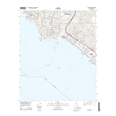
2015 Map of Dana Point
USGS Topo · Published 2015About this map
San Juan Capistrano and the coastal communities of Orange County are shown during a period of dense residential development along the Pacific shoreline. This topographical record details the complex drainage patterns of the coastal hills, where canyons like Deep Canyon and seasonal watercourses such as Arroyo Trabuco and San Juan Cr meet the sea. The map documents the intricate street networks that have filled the spaces between historic landmarks like Dana Point and the sprawling southern reaches of San Clemente. Along the coast, numerous distinct beach segments are identified, from Three Arch Bay in the north to the San Clemente City Beach at the southern edge. The inclusion of the Avalon-Dana Point Fry route highlights the area's continued role as a maritime transit hub, connecting the mainland to the offshore islands across the Pacific Ocean.
Find a feature on this map
32 named features on this map. Tap any name to fly to it.
Don’t see what you’re looking for? This feature index may not catch every label — zoom into the map to look around manually.
Map Details
Editions of this 2015 Dana Point Map
This is the sole edition of this map. No revisions or reprints were ever made.
Other maps of this area

1896 · Santa Ana
USGS Topo · 1:62,500

1901 · Southern California Sheet No. 1
USGS Topo · 1:250,000

1901 · Santa Ana
USGS Topo · 1:62,500

1902 · Capistrano
USGS Topo · 1:125,000

1902 · Corona
USGS Topo · 1:125,000

1904 · Southern California Sheet No. 2
USGS Topo · 1:250,000

1904 · Southern California Sheet No. 1
USGS Topo · 1:250,000

1906 · Capistrano
USGS Topo · 1:125,000

1942 · San Juan Capistrano
USGS Topo · 1:62,500
1942 · Santa Ana
USGS Topo · 1:62,500