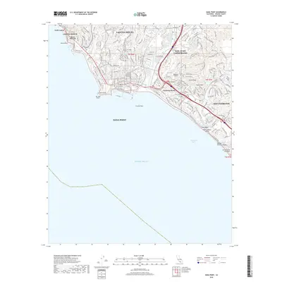
2018 Map of Dana Point
USGS Topo · Published 2018About this map
The coastal communities of southern Orange County are depicted in high detail during the late 2010s, showing a densely developed landscape where the Santa Ana Mountains meet the Pacific Ocean. This survey highlights the complex suburban layout of Laguna Niguel and San Juan Capistrano, where residential growth has filled the valleys surrounding the drainage of San Juan Creek. The map provides a clear look at the proximity of older coastal enclaves like Three Arch Bay and South Laguna to the modern residential corridors. Along the shoreline, the historic Pacific Coast Hwy and El Camino Real serve as primary arteries, linking Capistrano Beach and San Clemente. Inland, the terrain is defined by ridgelines like Folsom Ridge and canyons such as Deep Canyon, with a notable network of recreational paths including the Forster Canyon Trail Patriot Trail and Las Ramblas Trail.
Find a feature on this map
38 named features on this map. Tap any name to fly to it.
Don’t see what you’re looking for? This feature index may not catch every label — zoom into the map to look around manually.
Map Details
Editions of this 2018 Dana Point Map
This is the sole edition of this map. No revisions or reprints were ever made.
Other maps of this area

1896 · Santa Ana
USGS Topo · 1:62,500

1901 · Southern California Sheet No. 1
USGS Topo · 1:250,000

1901 · Santa Ana
USGS Topo · 1:62,500

1902 · Capistrano
USGS Topo · 1:125,000

1902 · Corona
USGS Topo · 1:125,000

1904 · Southern California Sheet No. 2
USGS Topo · 1:250,000

1904 · Southern California Sheet No. 1
USGS Topo · 1:250,000

1906 · Capistrano
USGS Topo · 1:125,000

1942 · San Juan Capistrano
USGS Topo · 1:62,500
1942 · Santa Ana
USGS Topo · 1:62,500