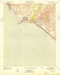
1949 Map of Dana Point
USGS Topo · Published 1949About this map
Dana Point and the neighboring coastal bluffs of Orange County appear here just after the post-war building boom began. The landscape is defined by the steep transition from the Gulf of Santa Catalina to the ridges of Niguel and Boca De La Playa. At this time, the Atchison Topeka and Santa Fe railroad tracks hug the narrow shoreline, passing through Capistrano Beach and onward toward San Clemente. Local aviation history is marked by the presence of the Capistrano Airport and a hilltop Airway Beacon overlooking Dana Cove. The map reveals early residential footprints in South Laguna and Three Arch Bay, while much of the inland terrain remains divided by canyons like Deep Canyon and Prima Deshecha. Public recreational space is already established at Doheny Beach State Park, situated where San Juan Creek meets the Pacific.
Find a feature on this map
35 named features on this map. Tap any name to fly to it.
Don’t see what you’re looking for? This feature index may not catch every label — zoom into the map to look around manually.
Map Details
Editions of this 1949 Dana Point Map
This is the sole edition of this map. No revisions or reprints were ever made.
Other maps of this area

1896 · Santa Ana
USGS Topo · 1:62,500

1901 · Southern California Sheet No. 1
USGS Topo · 1:250,000

1901 · Santa Ana
USGS Topo · 1:62,500

1902 · Capistrano
USGS Topo · 1:125,000

1902 · Corona
USGS Topo · 1:125,000

1904 · Southern California Sheet No. 2
USGS Topo · 1:250,000

1904 · Southern California Sheet No. 1
USGS Topo · 1:250,000

1906 · Capistrano
USGS Topo · 1:125,000

1942 · San Juan Capistrano
USGS Topo · 1:62,500
1942 · Santa Ana
USGS Topo · 1:62,500