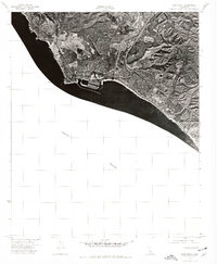
1974 Map of Dana Point
USGS Topo · Published 1977About this map
San Clemente sits at the southeastern edge of this 1974 orthophotograph, showing the dense residential and commercial expansion along the coast of Orange County. This specific imagery, captured by the Pacific Ocean, reveals the intricate harbor development at Dana Point and the complex network of suburban streets and interstate infrastructure that came to define this part of Southern California in the mid-1970s. The orthophoto format provides a clear view of the land-use patterns, from the organized marina slips to the developing hillside neighborhoods and the prominent highway corridor that connects these coastal communities. It offers an unfiltered look at the landscape just as the region was undergoing a period of intense suburban growth and coastal engineering.
Find a feature on this map
2 named features on this map. Tap any name to fly to it.
Don’t see what you’re looking for? This feature index may not catch every label — zoom into the map to look around manually.
Map Details
Editions of this 1974 Dana Point Map
This is the sole edition of this map. No revisions or reprints were ever made.
Other maps of this area

1896 · Santa Ana
USGS Topo · 1:62,500

1901 · Southern California Sheet No. 1
USGS Topo · 1:250,000

1901 · Santa Ana
USGS Topo · 1:62,500

1902 · Capistrano
USGS Topo · 1:125,000

1902 · Corona
USGS Topo · 1:125,000

1904 · Southern California Sheet No. 2
USGS Topo · 1:250,000

1904 · Southern California Sheet No. 1
USGS Topo · 1:250,000

1906 · Capistrano
USGS Topo · 1:125,000

1942 · San Juan Capistrano
USGS Topo · 1:62,500
1942 · Santa Ana
USGS Topo · 1:62,500