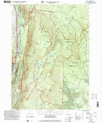
1997 Map of Danby
USGS Topo · Published 2000About this map
Danby and the village of South End occupy the narrow valley floor where the Vermont Railway and U.S. Highway 7 parallel the path of Otter Creek. This 1990s U.S. Forest Service revision reveals a landscape heavily defined by protected lands, including the Green Mountain National Forest and the Big Branch Wilderness. The map serves as a detailed record of high-altitude features and backcountry infrastructure, showing the Appalachian Long Trail as it traverses ridges between Baker Peak and Styles Peak. Significant local history is found at the South End Cem and the Mount Tabor Work Center, while the presence of the Old Job site and multiple shelters like Big Branch Shelter and Peru Peak Shelter point to the area's long-standing connection to timber harvesting and recreational hiking. Water features such as Griffith Lake and Hapgood Pond are vital landmarks within the dense forest blocks.
Find a feature on this map
56 named features on this map. Tap any name to fly to it.
Don’t see what you’re looking for? This feature index may not catch every label — zoom into the map to look around manually.
Map Details
Editions of this 1997 Danby Map
This is the sole edition of this map. No revisions or reprints were ever made.
Other maps of this area

1893 · Wallingford
USGS Topo · 1:62,500

1894 · Londonderry
USGS Topo · 1:62,500

1894 · Pawlet
USGS Topo · 1:62,500

1894 · Equinox
USGS Topo · 1:62,500

1896 · Equinox
USGS Topo · 1:62,500

1897 · Pawlet
USGS Topo · 1:62,500

1899 · Londonderry
USGS Topo · 1:62,500

1900 · Equinox
USGS Topo · 1:62,500

1903 · Mettawee
USGS Topo · 1:125,000

1950 · Glens Falls
USGS Topo · 1:250,000