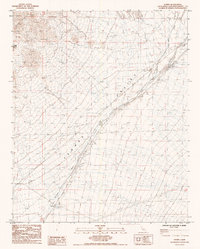
1985 Map of Danby
USGS Topo · Published 1985About this map
Danby sits at the junction of rail and desert drainage in this mid-1980s survey of the Mojave. The Atchison Topeka and Santa Fe railroad cuts a straight line across the landscape, paralleled by an Underground Pipeline and protected by occasional levees against the seasonal flows of Schuyler Wash. The terrain is defined by the broad Fenner Valley, which is framed by the dramatic heights of the Old Woman Mountains and the distinct peak of Castle Dome. Local industrial activity is evidenced by several prospects located in the higher elevations, while a network of 4wd trails suggests the persistent use of the area by miners and desert travelers. This map captures the stark infrastructure of the high desert, where transport corridors are dictated by the natural paths of Watson Wash and the surrounding mountain ranges.
Find a feature on this map
15 named features on this map. Tap any name to fly to it.
Don’t see what you’re looking for? This feature index may not catch every label — zoom into the map to look around manually.
Map Details
Editions of this 1985 Danby Map
This is the sole edition of this map. No revisions or reprints were ever made.
Other maps of this area

1942 · Amboy
USGS Topo · 1:250,000

1943 · Amboy
USGS Topo · 1:250,000

1943 · Essex
USGS Topo · 1:62,500

1943 · Danby
USGS Topo · 1:62,500

1943 · Fenner
USGS Topo · 1:62,500

1954 · Needles
USGS Topo · 1:250,000

1956 · Needles
USGS Topo · 1:250,000

1956 · Fenner
USGS Topo · 1:62,500

1956 · Essex
USGS Topo · 1:62,500

1956 · Colton Well
USGS Topo · 1:62,500