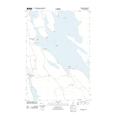
2011 Map of Danforth
USGS Topo · Published 2011About this map
Danforth serves as the primary hub in this Maine landscape, where the Danforth Post Office and local civic institutions like the Grand Lake Grange anchor the community's activity. The area's geography is defined by a vast water network, including the expansive Grand Lake and Brackett Lake, which are connected by a series of points and coves such as Mattigan Point and Dark Cove. The movement of water is managed at the Crooked Brook Dam, while Baskahegan Stream and Sandy Brook drain the surrounding woodlands. Genealogists and local researchers will find the Danforth Cemetery and Butterfield Cemetery clearly marked near the primary settlements. The presence of Butterfield Landing and the Two Mile Curve along the roadway suggests a region long shaped by its proximity to the lakeshore and the practical requirements of transporting goods and people through the timber-rich Maine interior.
Find a feature on this map
47 named features on this map. Tap any name to fly to it.
Don’t see what you’re looking for? This feature index may not catch every label — zoom into the map to look around manually.
Map Details
Editions of this 2011 Danforth Map
This is the sole edition of this map. No revisions or reprints were ever made.
Other maps of this area

1940 · Danforth
USGS Topo · 1:62,500

1940 · Amity
USGS Topo · 1:62,500

1940 · Forest
USGS Topo · 1:62,500

1941 · Danforth
USGS Topo · 1:62,500

1941 · Amity
USGS Topo · 1:62,500

1942 · Forest
USGS Topo · 1:62,500

1943 · Danforth
USGS Topo · 1:62,500

1943 · Amity
USGS Topo · 1:62,500

1957 · Fredericton
USGS Topo · 1:250,000
1958 · Danforth
USGS Topo · 1:62,500