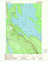
1988 Map of Danforth
USGS Topo · Published 1988About this map
The town of Danforth and the neighboring settlement of Weston sit along the western edge of the international boundary in this late-1980s landscape. This region of Maine is defined by the intricate waterways of Chiputneticook Grand Lake and North Lake, where the border between the United States and Canada runs through open water and past numerous points like Greenland Pt and Hayes Point. Cultural landmarks such as the Grand Lake Grange and the Butterfield Landing Boat Ramp suggest a community oriented toward the water and local agricultural organization. The terrain is dominated by prominent elevations like Greenland Ridge and Pemberton Ridge, which overlook a series of coves and islands, including Billy Island and Nan Island. Moving south, the small settlement of Flagstaff is found near Greenland Cove, illustrating the scattered nature of habitation in this heavily forested borderland.
Find a feature on this map
56 named features on this map. Tap any name to fly to it.
Don’t see what you’re looking for? This feature index may not catch every label — zoom into the map to look around manually.
Map Details
Editions of this 1988 Danforth Map
This is the sole edition of this map. No revisions or reprints were ever made.
Other maps of this area

1940 · Danforth
USGS Topo · 1:62,500

1940 · Amity
USGS Topo · 1:62,500

1940 · Forest
USGS Topo · 1:62,500

1941 · Danforth
USGS Topo · 1:62,500

1941 · Amity
USGS Topo · 1:62,500

1942 · Forest
USGS Topo · 1:62,500

1943 · Danforth
USGS Topo · 1:62,500

1943 · Amity
USGS Topo · 1:62,500

1957 · Fredericton
USGS Topo · 1:250,000
1958 · Danforth
USGS Topo · 1:62,500