
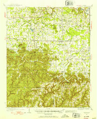
1935 Map of Danville
USGS Topo · Published 1935About this map
The Alabama National Forest dominates the southern landscape of this mid-1930s survey, where the convergence of Lawrence, Morgan, Winston, and Cullman counties creates a complex terrain of named peaks and hollows. The presence of Indian Mounds near Oakville points to a deep history of indigenous habitation long before the 20th-century settlements like Danville and Neel were established.
Find a feature on this map
87 named features on this map. Tap any name to fly to it.
Don’t see what you’re looking for? This feature index may not catch every label — zoom into the map to look around manually.
Map Details
Editions of this 1935 Danville Map
2 editions found
Other maps of this area

1888 · Cullman
USGS Topo · 1:125,000

1888 · Huntsville
USGS Topo · 1:125,000

1892 · Cullman
USGS Topo · 1:125,000

1892 · Huntsville
USGS Topo · 1:125,000

1927 · Falkville
USGS Topo · 1:24,000

1935 · Moulton
USGS Topo · 1:24,000

1935 · Upshaw
USGS Topo · 1:24,000

1935 · Oakville
USGS Topo · 1:24,000

1936 · Caddo
USGS Topo · 1:24,000

1936 · Mc Kendry
USGS Topo · 1:24,000