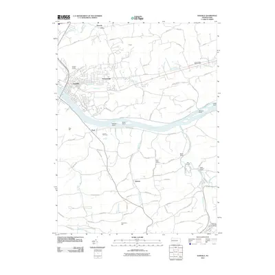
2010 Map of Danville
USGS Topo · Published 2010About this map
The Susquehanna River flows through the heart of this landscape, its channel divided by Vastines Island, Reeds Island, and Menches Island. The borough of Danville anchors the northwest, where Sechler Run and Blizzards Run meet the river. Small settlements like Mechanicsville, Kaseville, and Quitman are scattered through the valleys, connected by a network of rural roads that navigate the distinct ridges and hills, including Blue Hill and Shamokin Hill.
Find a feature on this map
79 named features on this map. Tap any name to fly to it.
Don’t see what you’re looking for? This feature index may not catch every label — zoom into the map to look around manually.
Map Details
Editions of this 2010 Danville Map
This is the sole edition of this map. No revisions or reprints were ever made.
Other maps of this area

1889 · Catawissa
USGS Topo · 1:62,500

1892 · Catawissa
USGS Topo · 1:62,500

1892 · Shamokin
USGS Topo · 1:62,500

1893 · Shamokin
USGS Topo · 1:62,500

1894 · Catawissa
USGS Topo · 1:62,500

1894 · Bloomsburg
USGS Topo · 1:62,500

1935 · Hughesville
USGS Topo · 1:62,500

1943 · Shamokin
USGS Topo · 1:62,500

1947 · Bloomsburg
USGS Topo · 1:24,000
1947 · Mt. Carmel
USGS Topo · 1:24,000
Featured Places
- Elysburg, Ralpho Township
- Valley Township, PA
- Rush Township, PA
- Boyd, Rush Township
- Roaring Creek, Mayberry Township