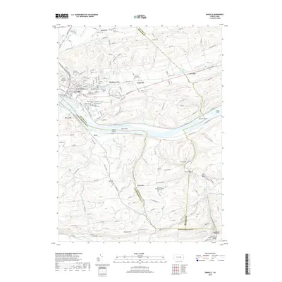
2019 Map of Danville
USGS Topo · Published 2019About this map
The Susquehanna River bends sharply south of Danville, serving as the geographical anchor for this part of central Pennsylvania. The river is dotted with landforms such as Vastines Island and Menches Island, while the surrounding terrain is defined by the prominent Sharp Ridge and The Pinnacle. In Danville, the Montour County Courthouse stands near a concentration of early burial grounds and religious sites, including the Old Presbyterian Church Cem and the Sisters of Saints Cyril and Methodius Cem. To the south, the landscape transitions into the hills of Shamokin Hill, where smaller communities like Quitman and Knoebels Grove are situated. The area's rural heritage is preserved through landmarks like the Riegel Covered Bridge and the Lawrence L Knoebel Covered Bridge spanning the branches of Roaring Creek.
Find a feature on this map
154 named features on this map. Tap any name to fly to it.
Don’t see what you’re looking for? This feature index may not catch every label — zoom into the map to look around manually.
Map Details
Editions of this 2019 Danville Map
This is the sole edition of this map. No revisions or reprints were ever made.
Other maps of this area

1889 · Catawissa
USGS Topo · 1:62,500

1892 · Catawissa
USGS Topo · 1:62,500

1892 · Shamokin
USGS Topo · 1:62,500

1893 · Shamokin
USGS Topo · 1:62,500

1894 · Catawissa
USGS Topo · 1:62,500

1894 · Bloomsburg
USGS Topo · 1:62,500

1935 · Hughesville
USGS Topo · 1:62,500

1943 · Shamokin
USGS Topo · 1:62,500

1947 · Bloomsburg
USGS Topo · 1:24,000
1947 · Mt. Carmel
USGS Topo · 1:24,000
Featured Places
- Elysburg, Ralpho Township
- Valley Township, PA
- Rush Township, PA
- Boyd, Rush Township
- Roaring Creek, Mayberry Township