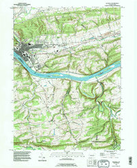
1994 Map of Danville
USGS Topo · Published 1996About this map
The Susquehanna River dominates this landscape, punctuated by a series of islands including Reeds Island, Vastines Island, and Menches Island. Along its north bank, the borough of Danville serves as a dense civic hub, featuring the prominent Geisinger Hospital complex, the Courthouse, and religious institutions like St Cyrils Academy and the Holy Family Convent. The surrounding terrain of Mahoning and West Hemlock is characterized by narrow valleys and steep ridges such as Sharp Ridge and The Pinnacle. To the south, the extensive grounds of the State Hospital overlook the river, while smaller settlements like Riverside, Mechanicsville, and Grovania are connected by roads following the contours of the Mahoning valley. The presence of several historic country churches, including Straub Ch and St Johns Ch (Cant), alongside numerous family cemeteries like Wilson Cem, highlights the long-established rural community structure in this part of Montour and Northumberland counties.
Find a feature on this map
83 named features on this map. Tap any name to fly to it.
Don’t see what you’re looking for? This feature index may not catch every label — zoom into the map to look around manually.
Map Details
Editions of this 1994 Danville Map
This is the sole edition of this map. No revisions or reprints were ever made.
Other maps of this area

1889 · Catawissa
USGS Topo · 1:62,500

1892 · Catawissa
USGS Topo · 1:62,500

1892 · Shamokin
USGS Topo · 1:62,500

1893 · Shamokin
USGS Topo · 1:62,500

1894 · Catawissa
USGS Topo · 1:62,500

1894 · Bloomsburg
USGS Topo · 1:62,500

1935 · Hughesville
USGS Topo · 1:62,500

1943 · Shamokin
USGS Topo · 1:62,500

1947 · Bloomsburg
USGS Topo · 1:24,000
1947 · Mt. Carmel
USGS Topo · 1:24,000
Featured Places
- Elysburg, Ralpho Township
- Rush Township, PA
- Boyd, Rush Township
- Grovania, Montour Township
- Franklin Township, PA