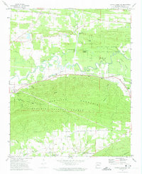
1972 Map of Danville Mountain
USGS Topo · Published 1974About this map
The Petit Jean River meanders across this 1970s landscape, defining a corridor of diverse land use from the northern slopes of Danville Mountain to the flatlands of the Petit Jean River State Wildlife Management Area. The Chicago Rock Island and Pacific railroad serves as the primary industrial artery, connecting the settlement of Danville with smaller locales such as Mickles. The map illustrates a transition from the structured forestry of the Quachita National Forest in the south to the fertile river valley, where water features like Cane Island and Surrounded Ridges Lake dominate the geography.
Find a feature on this map
41 named features on this map. Tap any name to fly to it.
Don’t see what you’re looking for? This feature index may not catch every label — zoom into the map to look around manually.
Map Details
Editions of this 1972 Danville Mountain Map
This is the sole edition of this map. No revisions or reprints were ever made.
Other maps of this area

1888 · Dardanelle #4
USGS Topo · 1:62,500

1888 · Dardanelle #3
USGS Topo · 1:62,500

1890 · Hot Springs
USGS Topo · 1:125,000

1890 · Dardanelle
USGS Topo · 1:125,000

1894 · Hot Springs
USGS Topo · 1:125,000

1955 · Little Rock
USGS Topo · 1:250,000

1956 · Little Rock
USGS Topo · 1:250,000

1956 · Russellville
USGS Topo · 1:250,000

1960 · Little Rock
USGS Topo · 1:250,000

1964 · Russellville
USGS Topo · 1:250,000