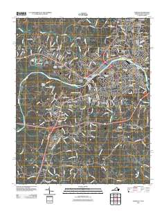
2011 Map of Danville
USGS Topo · Published 2011About this map
The Dan River serves as the central artery for this Virginia-North Carolina borderland, anchoring the city of Danville and its surrounding mid-century neighborhoods. This 2011 survey highlights a dense landscape of suburban expansion, from Westover Hills in the north to Stokesland in the south, while preserving significant commemorative sites like the National Cemetery and Freedmens Cemetery. The area's industrial and utilitarian infrastructure is visible through features like the Schoolfield Dam and the Shelton Quarry, alongside various transportation corridors including the Norfolk Southern rail line.
Find a feature on this map
192 named features on this map. Tap any name to fly to it.
Don’t see what you’re looking for? This feature index may not catch every label — zoom into the map to look around manually.
Map Details
Editions of this 2011 Danville Map
This is the sole edition of this map. No revisions or reprints were ever made.
Other maps of this area

1923 · Danville
USGS Topo · 1:48,000

1924 · Draper
USGS Topo · 1:48,000

1925 · Danville
USGS Topo · 1:62,500

1926 · Draper
USGS Topo · 1:62,500

1944 · Draper
USGS Topo · 1:62,500

1953 · Greensboro
USGS Topo · 1:250,000

1954 · Greensboro
USGS Topo · 1:250,000

1962 · Greensboro
USGS Topo · 1:250,000

1964 · Mount Hermon
USGS Topo · 1:24,000
1964 · Blairs
USGS Topo · 1:24,000