
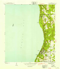
1941 Map of Daphne
USGS Topo · Published 1941About this map
The Eastern Shore Boulevard traces the high bluffs of Baldwin County in this 1939 survey, revealing a landscape of coastal settlements and agricultural research stations before the era of modern suburban expansion. The community of Daphne serves as a primary hub, anchored by the State Teachers College and the Baldwin County Training School. Further south, the town of Fairhope is clearly defined by its grid of streets terminating at the Municipal Wharf, a vital link to maritime activity on Mobile Bay. Along the shore, smaller pockets of development like Montrose, Seacliff, and Magnolia Beach are punctuated by steep terrain such as Red Bluff. Inland, the Gulf Coast Experiment Station and rural landmarks like Lebanon Chapel and the Anna T Jeanes Sch indicate the region's historical reliance on both education and agricultural science.
Find a feature on this map
30 named features on this map. Tap any name to fly to it.
Don’t see what you’re looking for? This feature index may not catch every label — zoom into the map to look around manually.
Map Details
Editions of this 1941 Daphne Map
2 editions found
Other maps of this area

1921 · Point Clear
USGS Topo · 1:62,500

1921 · Fairhope
USGS Topo · 1:62,500

1921 · Delchamps
USGS Topo · 1:62,500

1922 · Mobile
USGS Topo · 1:62,500

1939 · Daphne
USGS Topo · 1:31,680

1940 · Silverhill
USGS Topo · 1:31,680

1940 · Hollingers Island
USGS Topo · 1:31,680

1940 · Mobile
USGS Topo · 1:31,680

1940 · Mobile
USGS Topo · 1:62,500

1941 · Silverhill
USGS Topo · 1:31,680