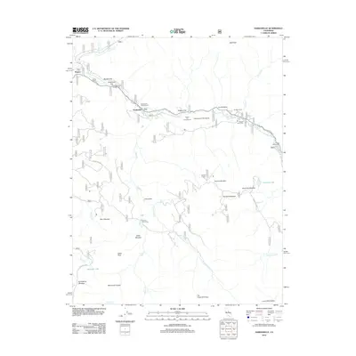
2012 Map of Dardanelle
USGS Topo · Published 2012About this map
The Middle Fork Stanislaus River carves through this high-altitude landscape, defining a corridor of seasonal activity and geologic interest. Along its banks, flat clearings such as Boulder Flat and Pidgeon Flat have historically supported campers and travelers, while the striking Columns of the Giants stands as a primary landmark. High-country meadows like Eagle Meadow, Sardine Meadow, and Red Rock Meadow dot the terrain, reflecting the area's history of summer grazing and recreation. Traces of human presence are found at Wagner and Martins Cow Camp, connected by forest routes and trails that weave between prominent summits like Eagle Peak and Bald Peak. From the basin of Haypress Lake to the secluded McCormick Pocket, the map documents a network of mountain roads and remote outposts within the central Sierra Nevada.
Find a feature on this map
43 named features on this map. Tap any name to fly to it.
Don’t see what you’re looking for? This feature index may not catch every label — zoom into the map to look around manually.
Map Details
Editions of this 2012 Dardanelle Map
This is the sole edition of this map. No revisions or reprints were ever made.
Other maps of this area

1896 · Dardanelles
USGS Topo · 1:125,000

1898 · Dardanelles
USGS Topo · 1:125,000

1948 · Walker Lake
USGS Topo · 1:250,000

1956 · Dardanelles Cone
USGS Topo · 1:62,500

1956 · Pinecrest
USGS Topo · 1:62,500

1956 · Sonora Pass
USGS Topo · 1:62,500
1956 · Tower Peak
USGS Topo · 1:62,500

1957 · Walker Lake
USGS Topo · 1:250,000

1962 · Walker Lake
USGS Topo · 1:250,000

1964 · Walker Lake
USGS Topo · 1:250,000