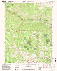
2001 Map of Dardanelle
USGS Topo · Published 2004About this map
The Middle Fork Stanislaus River carves through this high-country landscape, serving as a corridor for seasonal settlements and recreation just after the turn of the 21st century. Along its course, small outposts like Dardanelle, Douglas Resort, and Baker Station mark the human footprint within the larger Stanislaus National Forest. The map detail highlights a transition between managed forest and protected wilderness, with the Carson-Iceberg Wilderness to the north and the Emigrant Wilderness to the south. Distinctive geological features such as the Columns of the Giants and Double Dome Rock overlook a network of seasonal meadows and pack camps, including Martins Cow Camp and Eagle Meadow Horse Camp. This survey reflects an era of carefully managed mountain resources, where logging and ranching history meet modern conservation, evidenced by the numerous prospect sites and the specialized Camp Jack Hazard.
Find a feature on this map
50 named features on this map. Tap any name to fly to it.
Don’t see what you’re looking for? This feature index may not catch every label — zoom into the map to look around manually.
Map Details
Editions of this 2001 Dardanelle Map
This is the sole edition of this map. No revisions or reprints were ever made.
Other maps of this area

1896 · Dardanelles
USGS Topo · 1:125,000

1898 · Dardanelles
USGS Topo · 1:125,000

1948 · Walker Lake
USGS Topo · 1:250,000

1956 · Dardanelles Cone
USGS Topo · 1:62,500

1956 · Pinecrest
USGS Topo · 1:62,500

1956 · Sonora Pass
USGS Topo · 1:62,500
1956 · Tower Peak
USGS Topo · 1:62,500

1957 · Walker Lake
USGS Topo · 1:250,000

1962 · Walker Lake
USGS Topo · 1:250,000

1964 · Walker Lake
USGS Topo · 1:250,000