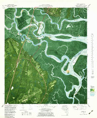
1979 Map of Darien
USGS Topo · Published 1979About this map
Darien and its surrounding coastal islands are captured here in a transition between historic agrarian footprints and modern conservation. The landscape is defined by the braided channels of the Altamaha River, including Butler River and Champney River, which carve through a network of marshy islands like Rhetts Island and Butler Island. Cultural layers are exceptionally dense, ranging from the colonial-era Old Fort King George and Santo Domingo Mission Ruins to sites reflecting the area's complex social history, such as the Hofwyl-Broadfield Plantation Historic Site. Genealogists will find significant value in the distribution of family and communal landmarks, including the Old Slave Cem Evelyn, Freedman Cem, and St Cyprians Ch. The southern portion of the sheet shifts toward 20th-century utility, dominated by the Glynco Jetport and the Federal Law Enforcement Training Center.
Find a feature on this map
77 named features on this map. Tap any name to fly to it.
Don’t see what you’re looking for? This feature index may not catch every label — zoom into the map to look around manually.
Map Details
Editions of this 1979 Darien Map
This is the sole edition of this map. No revisions or reprints were ever made.
Other maps of this area

1918 · Everett City
USGS Topo · 1:62,500

1918 · Bladen
USGS Topo · 1:62,500

1920 · Everett City
USGS Topo · 1:62,500

1921 · Darien
USGS Topo · 1:62,500

1939 · Bladen
USGS Topo · 1:62,500

1944 · Everett City
USGS Topo · 1:62,500

1945 · Brunswick
USGS Topo · 1:62,500

1946 · Brunswick
USGS Topo · 1:250,000

1948 · Brunswick
USGS Topo · 1:250,000

1954 · Altamaha Sound
USGS Topo · 1:24,000