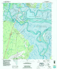
1993 Map of Darien
USGS Topo · Published 1995About this map
Darien and the river delta that defines it are captured here in a complex network of marshes, islands, and historical sites. The landscape is dominated by the Altamaha State Waterfowl Management Area, which spans numerous islands including Generals Island, Butler Island, and Rhetts Island. This intricate estuarine environment reflects centuries of coastal history, from the Fort King George State Historic Site at the mouth of the Darien River to the Santo Domingo Mission Ruins further inland. Genealogy and local history are preserved through numerous burial grounds such as Indian Cem, the Old Slave Cem, and Freedman Cem. To the south, the transition into industrial and modern use is evident at the Glynco Jetport and the Federal Law Enforcement Training Center, marking the boundary between McIntosh and Glynn counties.
Find a feature on this map
56 named features on this map. Tap any name to fly to it.
Don’t see what you’re looking for? This feature index may not catch every label — zoom into the map to look around manually.
Map Details
Editions of this 1993 Darien Map
This is the sole edition of this map. No revisions or reprints were ever made.
Other maps of this area

1918 · Everett City
USGS Topo · 1:62,500

1918 · Bladen
USGS Topo · 1:62,500

1920 · Everett City
USGS Topo · 1:62,500

1921 · Darien
USGS Topo · 1:62,500

1939 · Bladen
USGS Topo · 1:62,500

1944 · Everett City
USGS Topo · 1:62,500

1945 · Brunswick
USGS Topo · 1:62,500

1946 · Brunswick
USGS Topo · 1:250,000

1948 · Brunswick
USGS Topo · 1:250,000

1954 · Altamaha Sound
USGS Topo · 1:24,000