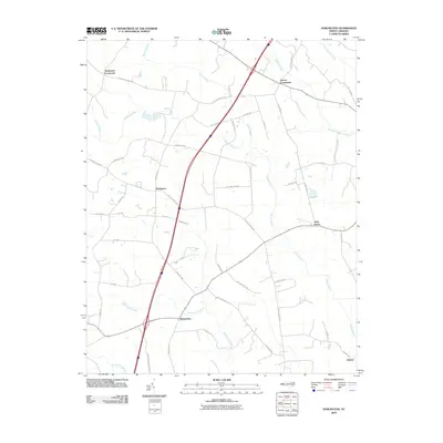
2010 Map of Darlington
USGS Topo · Published 2010About this map
Marsh Swamp and its numerous tributaries, including Martin Swamp and Beaverdam Swamp, dominate this part of Halifax County, creating a landscape defined by its intricate drainage patterns. The settlement at Darlington serves as a central point in a network of rural crossroads, joined by Andersons Crossroads to the northwest and Pierces Crossroads to the northeast. These small communities are connected by a web of named local routes like Aurelian Springs Rd and Ridgecrest Rd, which navigate the low-lying terrain between the creeks. To the south, the community of Beaverdam sits near the headwaters of its namesake swamp, while Allen Grove and Delmar anchor the eastern and southeastern reaches. The map reflects a modern rural infrastructure where established family-named roads and agrarian land use persist alongside contemporary highway developments.
Find a feature on this map
44 named features on this map. Tap any name to fly to it.
Don’t see what you’re looking for? This feature index may not catch every label — zoom into the map to look around manually.
Map Details
Editions of this 2010 Darlington Map
This is the sole edition of this map. No revisions or reprints were ever made.
Other maps of this area

1953 · Norfolk
USGS Topo · 1:250,000

1960 · Dawson Crossroads
USGS Topo · 1:24,000

1961 · Enfield
USGS Topo · 1:24,000

1963 · Ringwood
USGS Topo · 1:24,000

1973 · Aurelian Springs
USGS Topo · 1:24,000
1973 · Thelma
USGS Topo · 1:24,000

1974 · Halifax
USGS Topo · 1:24,000
1974 · Roanoke Rapids
USGS Topo · 1:24,000
1974 · Weldon
USGS Topo · 1:24,000

1974 · Darlington
USGS Topo · 1:24,000