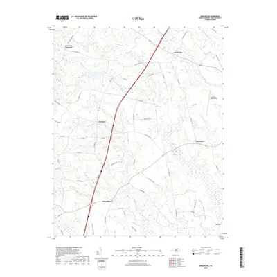
2019 Map of Darlington
USGS Topo · Published 2019About this map
Darlington and the rural communities of northern Halifax County are defined by a network of agricultural land and wetland systems in this 2019 survey. The landscape is structured by several prominent watercourses and swamp lands, including Marsh Swamp to the north and the extensive Beaverdam Swamp and Burnt Coat Swamp to the south. These natural features dictated the placement of historic settlements like Beaverdam and Delmar, which are situated on the higher ground between these drainages. Modern infrastructure is represented by the Halifax-Northampton Regional Airport and a major highway corridor that bisects the region, connecting Andersons Crossroads and Pierces Crossroads. Many local roads, such as Piney Grove Church Rd and Old Hotel Rd, provide clues to the locations of former community landmarks and commercial centers that once served these agrarian townships.
Find a feature on this map
52 named features on this map. Tap any name to fly to it.
Don’t see what you’re looking for? This feature index may not catch every label — zoom into the map to look around manually.
Map Details
Editions of this 2019 Darlington Map
This is the sole edition of this map. No revisions or reprints were ever made.
Other maps of this area

1953 · Norfolk
USGS Topo · 1:250,000

1960 · Dawson Crossroads
USGS Topo · 1:24,000

1961 · Enfield
USGS Topo · 1:24,000

1963 · Ringwood
USGS Topo · 1:24,000

1973 · Aurelian Springs
USGS Topo · 1:24,000
1973 · Thelma
USGS Topo · 1:24,000

1974 · Halifax
USGS Topo · 1:24,000
1974 · Roanoke Rapids
USGS Topo · 1:24,000
1974 · Weldon
USGS Topo · 1:24,000

1974 · Darlington
USGS Topo · 1:24,000