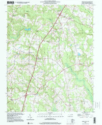
1998 Map of Darlington
USGS Topo · Published 2000About this map
Darlington and several named crossroads define the rural landscape of Halifax County at the close of the twentieth century. This area is characterized by its complex network of low-lying wetlands, including the expansive Marsh Swamp to the north and Burnt Coat Swamp to the south. The settlement pattern is deeply rooted in local institutions, evidenced by a high density of country churches such as Smith Chapel, Lebanon Ch, and Daniels Chapel. The presence of the Pittman Sch and various Cem sites provides essential data for genealogists tracing family footprints across these coastal plains.
Find a feature on this map
23 named features on this map. Tap any name to fly to it.
Don’t see what you’re looking for? This feature index may not catch every label — zoom into the map to look around manually.
Map Details
Editions of this 1998 Darlington Map
This is the sole edition of this map. No revisions or reprints were ever made.
Other maps of this area

1953 · Norfolk
USGS Topo · 1:250,000

1960 · Dawson Crossroads
USGS Topo · 1:24,000

1961 · Enfield
USGS Topo · 1:24,000

1963 · Ringwood
USGS Topo · 1:24,000

1973 · Aurelian Springs
USGS Topo · 1:24,000
1973 · Thelma
USGS Topo · 1:24,000

1974 · Halifax
USGS Topo · 1:24,000
1974 · Roanoke Rapids
USGS Topo · 1:24,000
1974 · Weldon
USGS Topo · 1:24,000

1974 · Darlington
USGS Topo · 1:24,000