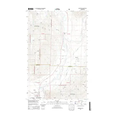
2014 Map of Darrington
USGS Topo · Published 2014About this map
The confluence of the Sauk River and the N Fork Stillaguamish River anchors this 2014 study of the mountain landscape where Skagit and Snohomish counties meet. Darrington serves as the primary hub, showing a developed street grid including Railroad Ave and Commercial Ave, as well as the Darrington Municipal Airport. The map documents the rural character of Sauk Prairie and the surrounding timberlands within the Mount Baker National Forest. Notable industrial and recreational landmarks include the Three Rivers Mill Pond, the Sauk River Bridge, and the Cascade Kamloops Trout Farm Recreational Vehicle Park. Higher elevations are defined by the peaks of North Mtn and Gold Mtn, while small settlements like Mansford and Andron mark the transitional spaces between the river valleys and the dense forest.
Find a feature on this map
51 named features on this map. Tap any name to fly to it.
Don’t see what you’re looking for? This feature index may not catch every label — zoom into the map to look around manually.
Map Details
Editions of this 2014 Darrington Map
This is the sole edition of this map. No revisions or reprints were ever made.
Other maps of this area

1899 · Glacier Peak
USGS Topo · 1:125,000

1899 · Stillaguamish
USGS Topo · 1:125,000

1901 · Glacier Peak
USGS Topo · 1:125,000

1901 · Stilaguamish
USGS Topo · 1:125,000

1955 · Concrete
USGS Topo · 1:250,000

1957 · Silverton
USGS Topo · 1:62,500

1958 · Concrete
USGS Topo · 1:250,000

1962 · Concrete
USGS Topo · 1:250,000
1966 · Darrington
USGS Topo · 1:24,000
1966 · White Chuck Mtn.
USGS Topo · 1:24,000