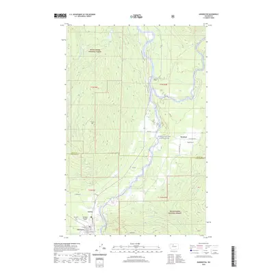
2020 Map of Darrington
USGS Topo · Published 2020About this map
The Sauk River valley defines this part of the Cascades, where the river's designation as the Skagit Wild and Scenic River reflects its importance to the regional ecosystem. At the southern edge of the map, Darrington serves as the primary hub, with its grid of streets such as Commercial Ave and Cascade St situated near the Darrington Municipal Airport and the Darrington Cem. The topography is dominated by the steep slopes of North Mtn and Gold Mtn, both part of the Mount Baker National Forest. Land use patterns here show a history of resource management, evidenced by the Three Rivers Mill-Pond and the network of forest roads like S Concrete Sauk Valley Rd. Small settlements like Mansford, Andron, and Sauk Prairie are positioned along the river flats and prairie lands, illustrating how early development followed the narrow habitable corridors between the mountains.
Find a feature on this map
43 named features on this map. Tap any name to fly to it.
Don’t see what you’re looking for? This feature index may not catch every label — zoom into the map to look around manually.
Map Details
Editions of this 2020 Darrington Map
This is the sole edition of this map. No revisions or reprints were ever made.
Other maps of this area

1899 · Glacier Peak
USGS Topo · 1:125,000

1899 · Stillaguamish
USGS Topo · 1:125,000

1901 · Glacier Peak
USGS Topo · 1:125,000

1901 · Stilaguamish
USGS Topo · 1:125,000

1955 · Concrete
USGS Topo · 1:250,000

1957 · Silverton
USGS Topo · 1:62,500

1958 · Concrete
USGS Topo · 1:250,000

1962 · Concrete
USGS Topo · 1:250,000
1966 · Darrington
USGS Topo · 1:24,000
1966 · White Chuck Mtn.
USGS Topo · 1:24,000