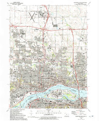
1991 Map of Davenport East
USGS Topo · Published 1992About this map
The Mississippi River serves as the focal point of this early 1990s survey, marking the border between Iowa and Illinois. The landscape is dominated by the industrial and military presence of the Rock Island Arsenal and Lock and Dam No 15, situated on Rock Island between Davenport and Rock Island city. The map reveals a dense urban corridor characterized by significant educational and medical institutions, including the Palmer College of Chiropractic and Augustana College. Transportation infrastructure is prominent, with the Soo Line railroad and Centennial Bridge connecting the Quad Cities. To the north, the terrain transitions toward suburban developments like Green Acres and Mt Joy, while the Davenport Muni Airport occupies the northwestern corner. Numerous religious and social landmarks, such as Oakdale Cemetery and Brady Street Stadium, highlight the long-established community structure of this riverfront region.
Find a feature on this map
62 named features on this map. Tap any name to fly to it.
Don’t see what you’re looking for? This feature index may not catch every label — zoom into the map to look around manually.
Map Details
Editions of this 1991 Davenport East Map
This is the sole edition of this map. No revisions or reprints were ever made.
Other maps of this area

1891 · Davenport
USGS Topo · 1:62,500

1892 · Leclaire
USGS Topo · 1:62,500

1893 · Leclaire
USGS Topo · 1:62,500

1894 · Davenport
USGS Topo · 1:62,500

1899 · Clinton
USGS Topo · 1:125,000

1901 · Rock Island
USGS Topo · 1:125,000

1910 · Rock Island
USGS Topo · 1:125,000

1912 · Milan
USGS Topo · 1:62,500

1937 · Orion
USGS Topo · 1:62,500

1944 · Milan
USGS Topo · 1:62,500