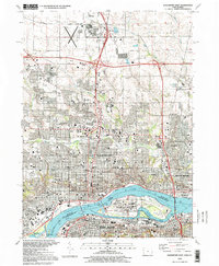
1993 Map of Davenport East
USGS Topo · Published 1999About this map
The Mississippi River serves as the central artery for this urban corridor during the 1990s, defining the industrial and civic boundaries between Iowa and Illinois. On the Iowa side, Davenport and Bettendorf exhibit dense residential grids interspersed with institutions like Palmer College of Chiropractic and St Ambrose College. The river itself is a hub of engineering and history, featuring Lock and Dam No 15 and the massive Rock Island Arsenal complex occupying the namesake island. To the south in Illinois, Rock Island and Moline front the Sylvan Slough, showing a landscape of rail yards, hospitals, and schools like Augustana College. A notable concentration of memorial sites appears on the island, including the Confederate Cem and National Cem, reflecting the area's deep federal and military ties. This era shows the mature development of the Quad Cities, from the Davenport Muni Airport in the north to the busy bridges connecting the urban cores.
Find a feature on this map
117 named features on this map. Tap any name to fly to it.
Don’t see what you’re looking for? This feature index may not catch every label — zoom into the map to look around manually.
Map Details
Editions of this 1993 Davenport East Map
This is the sole edition of this map. No revisions or reprints were ever made.
Other maps of this area

1891 · Davenport
USGS Topo · 1:62,500

1892 · Leclaire
USGS Topo · 1:62,500

1893 · Leclaire
USGS Topo · 1:62,500

1894 · Davenport
USGS Topo · 1:62,500

1899 · Clinton
USGS Topo · 1:125,000

1901 · Rock Island
USGS Topo · 1:125,000

1910 · Rock Island
USGS Topo · 1:125,000

1912 · Milan
USGS Topo · 1:62,500

1937 · Orion
USGS Topo · 1:62,500

1944 · Milan
USGS Topo · 1:62,500