Loading...
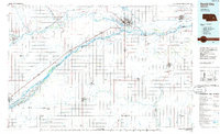
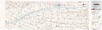
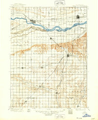
Loading map...1985 Map of David City
USGS Topo · Published 1985About this map
The Platte River and Loup River define the agricultural heartland of central Nebraska in this mid-1980s portrait. The landscape is structured by a grid of farm-to-market roads and the critical corridors of the Union Pacific and Burlington Northern railroads, which link established grain-handling hubs like David City and Columbus. Along the braided channels of the Platte, numerous named islands such as Hewitt Island and Tomek Island highlight the shifting nature of the river valley before modern hydrology fully altered these reaches.
Find a feature on this map
105 named features on this map. Tap any name to fly to it.
Don’t see what you’re looking for? This feature index may not catch every label — zoom into the map to look around manually.
Map Details
Date Portrayed1985
Date Published1985
PublisherU.S. Geological Survey
Map TypeTopographic
Scale1:100,000
Physical Dimensions39.6 x 24.1 inches
Editions of this 1985 David City Map
2 editions found
Historical Maps of Columbus Through Time
Featured Locations
Source Details
SourceU.S. Geological Survey
CopyrightPublic Domain