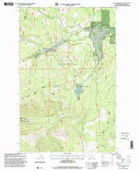
1997 Map of Davis Mountain
USGS Topo · Published 2000About this map
Kootenai National Forest dominates this northwestern Montana landscape, where the administrative boundary between the Fortine Ranger District and Fisher River Ranger District bisects the rugged drainage basins. At the southern edge of the map, the Davis Mountain Lookout provides a literal and figurative vantage point over a complex network of waterways, including North Fork Fivemile Creek and South Fork Fivemile Creek. The terrain is defined by dramatic elevation changes, rising toward summits like Sheep Mountain. Tracing the path of Sterling Creek or Swamp Creek reveals the interplay of high-altitude wetlands and timbered slopes, while the surveyed line of the 8th Standard Parallel North provides a precise historical anchor for the Public Land Survey System in this wilderness setting.
Find a feature on this map
20 named features on this map. Tap any name to fly to it.
Don’t see what you’re looking for? This feature index may not catch every label — zoom into the map to look around manually.
Map Details
Editions of this 1997 Davis Mountain Map
This is the sole edition of this map. No revisions or reprints were ever made.
Other maps of this area

1913 · Stryker
USGS Topo · 1:125,000

1916 · Stryker
USGS Topo · 1:125,000

1920 · Jennings
USGS Topo · 1:125,000

1935 · Thompson Lakes
USGS Topo · 1:96,000

1942 · Thompson Lakes
USGS Topo · 1:125,000

1957 · Kalispell
USGS Topo · 1:250,000

1960 · Kalispell
USGS Topo · 1:250,000

1961 · Kalispell
USGS Topo · 1:250,000

1963 · Mc Guire Mountain
USGS Topo · 1:24,000

1963 · Davis Mountain
USGS Topo · 1:24,000