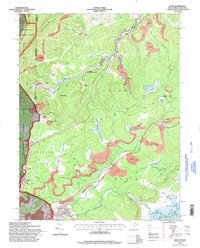
1995 Map of Davis
USGS Topo · Published 1998About this map
The Blackwater River and North Branch Potomac River carve through the high elevations of Backbone Mountain in this detailed survey of the West Virginia and Maryland border. The landscape is defined by the heavy footprint of extractive industry, with numerous strip mines and coal-related infrastructure like the tipple and mine dump near Henry. Significant historical markers, most notably the Fairfax Stone, sit near the headwaters, anchoring the territorial divisions between the states.
Find a feature on this map
53 named features on this map. Tap any name to fly to it.
Don’t see what you’re looking for? This feature index may not catch every label — zoom into the map to look around manually.
Map Details
Editions of this 1995 Davis Map
This is the sole edition of this map. No revisions or reprints were ever made.
Other maps of this area

1886 · St. George
USGS Topo · 1:125,000

1891 · St. George
USGS Topo · 1:125,000

1895 · Piedmont
USGS Topo · 1:125,000

1899 · Oakland
USGS Topo · 1:62,500

1900 · Oakland
USGS Topo · 1:62,500

1907 · Kingwood
USGS Topo · 1:62,500

1908 · Parsons
USGS Topo · 1:62,500

1916 · Davis
USGS Topo · 1:48,000

1918 · Davis
USGS Topo · 1:62,500

1919 · Davis
USGS Topo · 1:62,500