
1919 Map of Davis
USGS Topo · Published 1955About this map
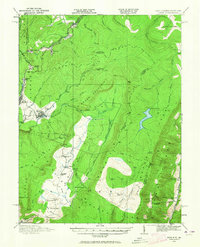
The Fairfax Stone marks the critical boundary intersection between West Virginia and Maryland, a historical survey point of immense importance for local genealogists and land researchers. This 1919-era landscape reveals the industrial activity that once dominated Tucker County, with the West Virginia Maryland RR and the extensive tracks of the Lumber RR spider-webbing through the high glades and mountain gaps. The town of Thomas and the settlement of Davis serve as central hubs, while the map preserves the locations of numerous vanished rural institutions, including the Accident School, Maple Grove School, and Harmon School. High-altitude terrain features like Backbone Mountain and Canaan Mountain surround the winding Blackwater River, illustrating the difficult geography that loggers and rail engineers navigated. The inclusion of family-named landmarks such as Bearden Knob and Rohrbaugh School provides specific touchpoints for tracing local ancestry within the Monongahela National Forest.
Find a feature on this map
64 named features on this map. Tap any name to fly to it.
Don’t see what you’re looking for? This feature index may not catch every label — zoom into the map to look around manually.
Map Details
Editions of this 1919 Davis Map
2 editions found
Other maps of this area

1886 · St. George
USGS Topo · 1:125,000

1889 · Beverly
USGS Topo · 1:125,000

1891 · St. George
USGS Topo · 1:125,000

1892 · Beverly
USGS Topo · 1:125,000

1892 · Franklin
USGS Topo · 1:125,000

1895 · Piedmont
USGS Topo · 1:125,000

1896 · Franklin
USGS Topo · 1:125,000

1899 · Oakland
USGS Topo · 1:62,500

1900 · Oakland
USGS Topo · 1:62,500

1907 · Kingwood
USGS Topo · 1:62,500