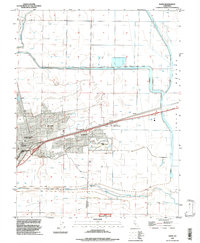
1992 Map of Davis
USGS Topo · Published 1997About this map
Davis serves as the focal point of this mapping of the Sacramento Valley in the early 1990s, dominated by the sprawling campus of the University of California. The landscape transitions from the dense street grids of the city to the expansive agricultural and hydrologic infrastructure of the Yolo Bypass. To the east of the university, smaller settlements like Chiles and El Macero line the rail corridor, while the Golf Course and residential developments indicate the suburban growth of the era.
Find a feature on this map
19 named features on this map. Tap any name to fly to it.
Don’t see what you’re looking for? This feature index may not catch every label — zoom into the map to look around manually.
Map Details
Editions of this 1992 Davis Map
This is the sole edition of this map. No revisions or reprints were ever made.
Other maps of this area

1907 · Woodland
USGS Topo · 1:62,500

1907 · Davisville
USGS Topo · 1:62,500

1908 · Vacaville
USGS Topo · 1:62,500

1908 · Courtland
USGS Topo · 1:62,500

1915 · Yolo
USGS Topo · 1:31,680

1915 · Swingle
USGS Topo · 1:31,680
1915 · Elkhorn Weir
USGS Topo · 1:31,680

1915 · Merritt
USGS Topo · 1:31,680

1916 · Dixon
USGS Topo · 1:31,680

1916 · Grays Bend
USGS Topo · 1:31,680