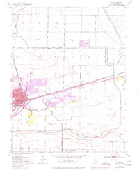
1975 Map of Davis
USGS Topo · Published 1977About this map
The Univ Of Calif campus and the growing residential neighborhoods of Davis dominate the western portion of this 1975 photorevision, which documents the expansion of this university town. Modern developments like El Macero and its associated Golf Course contrast with the long-established agricultural landscape and the heavy infrastructure required to manage the Central Valley floor. The intricate system of water control is visible through the massive Willow Slough Bypass and the engineered Levee system protecting the surrounding lowlands.
Find a feature on this map
26 named features on this map. Tap any name to fly to it.
Don’t see what you’re looking for? This feature index may not catch every label — zoom into the map to look around manually.
Map Details
Editions of this 1975 Davis Map
This is the sole edition of this map. No revisions or reprints were ever made.
Other maps of this area

1907 · Woodland
USGS Topo · 1:62,500

1907 · Davisville
USGS Topo · 1:62,500

1908 · Vacaville
USGS Topo · 1:62,500

1908 · Courtland
USGS Topo · 1:62,500

1915 · Yolo
USGS Topo · 1:31,680

1915 · Swingle
USGS Topo · 1:31,680
1915 · Elkhorn Weir
USGS Topo · 1:31,680

1915 · Merritt
USGS Topo · 1:31,680

1916 · Dixon
USGS Topo · 1:31,680

1916 · Grays Bend
USGS Topo · 1:31,680