
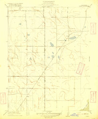
1916 Map of Dixon
USGS Topo · Published 1916About this map
Dixon serves as the central hub of this agricultural landscape in the mid-1910s, defined by its rigid grid system and its vital connection to the Southern Pacific (Ogden Line). This rail corridor cuts a sharp diagonal through the territory, linking the primary settlement of Dixon to smaller rail stops like Batavia to the southwest and Tremont at the northeastern corner. The map illustrates a highly organized rural economy where section lines and farm roads dictate the layout of the land.
Find a feature on this map
6 named features on this map. Tap any name to fly to it.
Don’t see what you’re looking for? This feature index may not catch every label — zoom into the map to look around manually.
Map Details
Editions of this 1916 Dixon Map
This is the sole edition of this map. No revisions or reprints were ever made.
Other maps of this area

1907 · Woodland
USGS Topo · 1:62,500

1907 · Davisville
USGS Topo · 1:62,500

1908 · Vacaville
USGS Topo · 1:62,500

1908 · Courtland
USGS Topo · 1:62,500

1915 · Swingle
USGS Topo · 1:31,680

1915 · Merritt
USGS Topo · 1:31,680

1916 · Cache Slough
USGS Topo · 1:31,680

1916 · Winters
USGS Topo · 1:31,680

1916 · Maine Prairie
USGS Topo · 1:31,680
1916 · Saxon
USGS Topo · 1:31,680