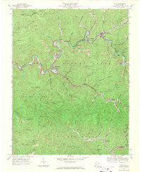
1968 Map of Davy
USGS Topo · Published 1971About this map
Tug Fork and its winding tributaries define this corridor of McDowell County, where coal-hauling infrastructure follows the narrow valley floors. The Norfolk and Western railway snakes through the landscape, connecting mining hubs like Davy, Roderfield, and Coalwood. This late-1960s survey captures the industrial footprint of the region, marked by numerous Gas Wells and Mines tucked into the hollows of Indian Ridge and Browns Creek. Local community life is anchored by landmarks such as Marytown Ch, the Langer Memorial Cem, and small settlements like Mohegan and Premier. High-elevation observation points, including the Coalwood Lookout Tower and Olga No 3 Lookout Tower, overlook a terrain deeply etched by Hensley Creek and the Sandy River, illustrating the logistical complexity of extraction and transport in southern West Virginia.
Find a feature on this map
52 named features on this map. Tap any name to fly to it.
Don’t see what you’re looking for? This feature index may not catch every label — zoom into the map to look around manually.
Map Details
Editions of this 1968 Davy Map
2 editions found
Other maps of this area

1891 · Tazewell
USGS Topo · 1:125,000

1891 · Oceana
USGS Topo · 1:125,000

1893 · Oceana
USGS Topo · 1:125,000

1895 · Tazewell
USGS Topo · 1:125,000

1897 · Tazewell
USGS Topo · 1:125,000

1898 · Oceana
USGS Topo · 1:125,000

1909 · Gilbert
USGS Topo · 1:48,000

1910 · Pineville
USGS Topo · 1:48,000

1910 · Iaeger
USGS Topo · 1:48,000

1912 · Gilbert
USGS Topo · 1:62,500