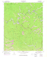
1968 Map of Davy
USGS Topo · Published 1977About this map
The Tug Fork and Norfolk and Western railway corridor define the industrial geography of this southern West Virginia landscape during the late 1960s and 1970s. This survey reveals a dense network of coal-related infrastructure, characterized by numerous mines, air shafts, and tipples concentrated around the settlements of Coalwood, Premier, and Davy. The topography is marked by ridges like Indian Ridge and Big Ridge, where lookout towers such as Coalwood Lookout Tower and Olga No 3 Lookout Tower provided vantage points over the narrow valleys. The presence of several family or local burial grounds, including the Iager Memorial Cem, alongside unincorporated communities like Twin Branch, Marytown, and Roderfield, provides critical spatial data for genealogists tracing the labor history of the Pocahontas Coalfield. Notable water features like Big Creek and Huff Creek intersect with the mountain terrain, illustrating how settlement followed the winding river bends and rail spurs.
Find a feature on this map
67 named features on this map. Tap any name to fly to it.
Don’t see what you’re looking for? This feature index may not catch every label — zoom into the map to look around manually.
Map Details
Editions of this 1968 Davy Map
2 editions found
Other maps of this area

1891 · Tazewell
USGS Topo · 1:125,000

1891 · Oceana
USGS Topo · 1:125,000

1893 · Oceana
USGS Topo · 1:125,000

1895 · Tazewell
USGS Topo · 1:125,000

1897 · Tazewell
USGS Topo · 1:125,000

1898 · Oceana
USGS Topo · 1:125,000

1909 · Gilbert
USGS Topo · 1:48,000

1910 · Pineville
USGS Topo · 1:48,000

1910 · Iaeger
USGS Topo · 1:48,000

1912 · Gilbert
USGS Topo · 1:62,500