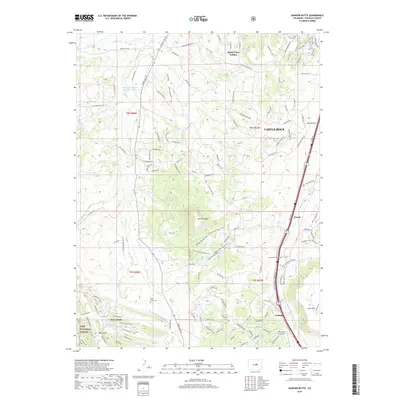
2019 Map of Dawson Butte
USGS Topo · Published 2019About this map
Dawson Butte rises as a prominent landmark in this Douglas County landscape, anchoring a network of recreational trails and ranching history. To the east, the Interstate 25 corridor connects the communities of Castle Rock, Tomah, and Larkspur, reflecting the modern development and transportation artery of the Colorado Front Range. This 2019 survey documents the expansion of residential developments such as Monte Vista Estates alongside traditional ranch lands and the rugged eastern boundary of the Pike National Forest. Genealogists and local historians will find interest in the Glen Grove Cem and established water features like Waucondah Reservoir and Stevens Reservoir Number 2 and 3. The southern portion of the map highlights the distinct planned community of Perry Park, integrated with the natural terrain of Hog John Gulch and serviced by the Perry Park Airport.
Find a feature on this map
131 named features on this map. Tap any name to fly to it.
Don’t see what you’re looking for? This feature index may not catch every label — zoom into the map to look around manually.
Map Details
Editions of this 2019 Dawson Butte Map
This is the sole edition of this map. No revisions or reprints were ever made.
Other maps of this area

1893 · Platte Canyon
USGS Topo · 1:125,000

1894 · Castle Rock
USGS Topo · 1:125,000

1913 · Castle Rock
USGS Topo · 1:125,000

1940 · Castle Rock
USGS Topo · 1:62,500

1945 · Castle Rock
USGS Topo · 1:62,500

1945 · Kassler
USGS Topo · 1:24,000

1948 · Kassler
USGS Topo · 1:24,000

1953 · Denver
USGS Topo · 1:250,000

1954 · Devils Head
USGS Topo · 1:24,000
1954 · Greenland
USGS Topo · 1:24,000