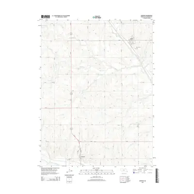
2014 Map of Dawson
USGS Topo · Published 2014About this map
Stella and Dawson anchor this rural Richardson County landscape, where the agricultural grid is defined by a complex network of creeks and drainage branches. The terrain is marked by the winding paths of Little Muddy Cr and Muddy Cr, which flow toward the southern border near the North Fork Big Nemaha River. This 2014 survey reveals a territory dense with ancestral markers, featuring numerous small cemeteries including Starr Cem, Mound Cem, and Stratton Cem tucked away between section roads.
Find a feature on this map
47 named features on this map. Tap any name to fly to it.
Don’t see what you’re looking for? This feature index may not catch every label — zoom into the map to look around manually.
Map Details
Editions of this 2014 Dawson Map
This is the sole edition of this map. No revisions or reprints were ever made.
Other maps of this area

1915 · Falls City
USGS Topo · 1:62,500

1915 · Nemaha
USGS Topo · 1:62,500

1915 · Howe
USGS Topo · 1:62,500

1916 · Humboldt
USGS Topo · 1:62,500

1939 · Nemaha
USGS Topo · 1:62,500

1949 · Nemaha
USGS Topo · 1:62,500

1955 · Nebraska City
USGS Topo · 1:250,000

1957 · Nebraska City
USGS Topo · 1:250,000

1958 · Nebraska City
USGS Topo · 1:250,000
1965 · Salem
USGS Topo · 1:24,000