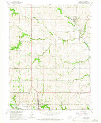
1965 Map of Dawson
USGS Topo · Published 1967About this map
Agricultural life in mid-century Richardson County centers on the rail-adjacent settlements of Stella and Dawson. These towns are connected by the Missouri Pacific and Chicago Burlington and Quincy railroads, which track through the drainage basins of the North Fork Big Nemaha River and its numerous tributaries. The landscape is marked by a dense distribution of rural institutions, including the Grand Avenue Sch, Hazel Dell Sch, and Mount Hope Sch, alongside local landmarks like the water tank in Dawson. This 1965 survey reveals a terrain defined by its watercourses, from the winding Little Muddy Creek to Whisky Run and Wolf Creek. Genealogists will find a wealth of local history in the numerous burial grounds documented, such as Stella Cem, Mound Cem, and St Marys Cem, which reflect the area's established family networks.
Find a feature on this map
35 named features on this map. Tap any name to fly to it.
Don’t see what you’re looking for? This feature index may not catch every label — zoom into the map to look around manually.
Map Details
Editions of this 1965 Dawson Map
This is the sole edition of this map. No revisions or reprints were ever made.
Other maps of this area

1915 · Falls City
USGS Topo · 1:62,500

1915 · Nemaha
USGS Topo · 1:62,500

1915 · Howe
USGS Topo · 1:62,500

1916 · Humboldt
USGS Topo · 1:62,500

1939 · Nemaha
USGS Topo · 1:62,500

1949 · Nemaha
USGS Topo · 1:62,500

1955 · Nebraska City
USGS Topo · 1:250,000

1957 · Nebraska City
USGS Topo · 1:250,000

1958 · Nebraska City
USGS Topo · 1:250,000
1965 · Salem
USGS Topo · 1:24,000