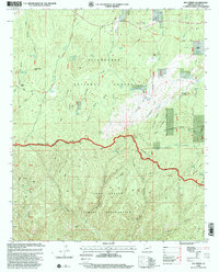
1998 Map of Day Spring
USGS Topo · Published 2000About this map
The dramatic Mogollon Rim escarpment divides this high-altitude landscape, marking the boundary between the Sitgreaves National Forest to the north and the Fort Apache Indian Reservation to the south. Historically significant routes crisscross the terrain, including the General George Crook Trail and the Old Verde Road, tracing the movement of early military and pioneer traffic through the pines. Small settlements and specialized camps such as Aripine PO and the Potato Patch highlight the scattered human presence in this forested region.
Find a feature on this map
63 named features on this map. Tap any name to fly to it.
Don’t see what you’re looking for? This feature index may not catch every label — zoom into the map to look around manually.
Map Details
Editions of this 1998 Day Spring Map
This is the sole edition of this map. No revisions or reprints were ever made.
Other maps of this area

1886 · Holbrook
USGS Topo · 1:250,000

1893 · Holbrook
USGS Topo · 1:250,000

1954 · Holbrook
USGS Topo · 1:250,000

1957 · Holbrook
USGS Topo · 1:250,000

1958 · Holbrook
USGS Topo · 1:250,000

1960 · Holbrook
USGS Topo · 1:250,000

1961 · Clay Springs
USGS Topo · 1:62,500

1961 · Heber
USGS Topo · 1:62,500

1961 · Cibecue
USGS Topo · 1:62,500

1961 · Chediski Peak
USGS Topo · 1:62,500