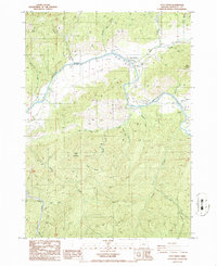
1986 Map of Days Creek
USGS Topo · Published 1986About this map
The South Umpqua River carves a winding path through this Douglas County landscape, serving as the primary geographic corridor for the settlement of Days Creek. This mid-1980s provisional study illustrates a region defined by its complex drainage network, where numerous tributaries like Slimwater Creek and Shiuely Creek feed into the river from the surrounding high ground. The terrain is marked by significant elevations such as Bland Mountain and Beals Mountain, with Hyde Ridge forming a prominent spine in the southern portion of the quadrangle.
Find a feature on this map
33 named features on this map. Tap any name to fly to it.
Don’t see what you’re looking for? This feature index may not catch every label — zoom into the map to look around manually.
Map Details
Editions of this 1986 Days Creek Map
This is the sole edition of this map. No revisions or reprints were ever made.
Other maps of this area

1897 · Roseburg
USGS Topo · 1:125,000

1900 · Roseburg
USGS Topo · 1:125,000

1904 · Riddle
USGS Topo · 1:125,000

1954 · Dixonville
USGS Topo · 1:62,500

1954 · Days Creek
USGS Topo · 1:62,500

1954 · Canyonville
USGS Topo · 1:62,500

1955 · Roseburg
USGS Topo · 1:62,500

1955 · Medford
USGS Topo · 1:250,000

1957 · Medford
USGS Topo · 1:250,000

1958 · Medford
USGS Topo · 1:250,000