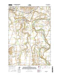
2017 Map of Dayton
USGS Topo · Published 2017About this map
Dayton and Lafayette anchor this Yamhill Valley landscape, where the meandering Yamhill River flows toward its confluence with the Willamette River. The area's agricultural history is reflected in the wide expanse of the Dayton Prairie and the productive French Prairie to the east. Genealogists will find several burial sites preserved across the landscape, including the Brookside Cem and the Independent Order of Odd Fellows Cem near Dayton, as well as the O'Dell Cem situated further south near Holdridge Cr. The river system defines the geography with numerous bars and bends such as Brentano Bar, Weston Bend, and Lower Lambert Bar, illustrating the complex shifting hydrology of the valley. Small settlements like Unionvale and Fairfield are connected by a network of rural roads such as SE Webfoot Rd and SE String Town Rd, while the Lafayette Airstrip serves the northern portion of the quadrangle.
Find a feature on this map
105 named features on this map. Tap any name to fly to it.
Don’t see what you’re looking for? This feature index may not catch every label — zoom into the map to look around manually.
Map Details
Editions of this 2017 Dayton Map
This is the sole edition of this map. No revisions or reprints were ever made.
Other maps of this area

1916 · Tualatin
USGS Topo · 1:62,500

1923 · Mount Angel
USGS Topo · 1:62,500

1924 · Mc Minnville
USGS Topo · 1:48,000

1926 · Mc Minnville
USGS Topo · 1:62,500

1939 · Tualatin
USGS Topo · 1:62,500

1940 · McMinnville
USGS Topo · 1:62,500

1940 · Tualatin
USGS Topo · 1:62,500

1940 · Mount Angel
USGS Topo · 1:62,500

1941 · Yamhill
USGS Topo · 1:62,500

1942 · Yamhill
USGS Topo · 1:62,500