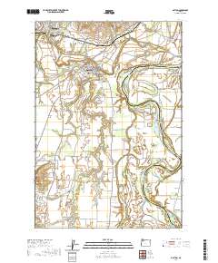
2020 Map of Dayton
USGS Topo · Published 2020About this map
The Willamette River and Yamhill River converge near Dayton, carving a complex landscape of bars and bends through this fertile portion of Yamhill County. The map documents a rich riverine environment where the water has shaped local geography into named features like Lambert Bend, Grand Island, and Five Islands. On the higher ground of the French Prairie and Dayton Prairie, the settlement pattern is established around historic community centers such as Unionvale and the town of Lafayette.
Find a feature on this map
111 named features on this map. Tap any name to fly to it.
Don’t see what you’re looking for? This feature index may not catch every label — zoom into the map to look around manually.
Map Details
Editions of this 2020 Dayton Map
This is the sole edition of this map. No revisions or reprints were ever made.
Other maps of this area

1916 · Tualatin
USGS Topo · 1:62,500

1923 · Mount Angel
USGS Topo · 1:62,500

1924 · Mc Minnville
USGS Topo · 1:48,000

1926 · Mc Minnville
USGS Topo · 1:62,500

1939 · Tualatin
USGS Topo · 1:62,500

1940 · McMinnville
USGS Topo · 1:62,500

1940 · Tualatin
USGS Topo · 1:62,500

1940 · Mount Angel
USGS Topo · 1:62,500

1941 · Yamhill
USGS Topo · 1:62,500

1942 · Yamhill
USGS Topo · 1:62,500