
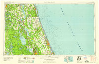
1958 Map of Daytona Beach
USGS Topo · Published 1958About this map
The Saint Johns River corridor anchors this late-1950s landscape, serving as a primary artery between the inland lake systems and the Atlantic coast. From the northern reach at St Augustine down to the growing corridor around Daytona Beach, the map captures the region's balance between riverside settlements like Palatka and the undeveloped wetlands of Big Fish Tail Swamp and Twelve Mile Swamp. To the west, the massive Ocala National Forest contrasts with the network of rail-dependent towns such as De Land and Crescent City, which grew around the Florida East Coast RR and Atlantic Coast Line RR. The coastal barrier islands, including Anastasia Island, show the early footprints of tourism at Marineland and the natural break at Ponce de Leon Inlet, reflecting Florida’s mid-century transition from a river-and-rail economy toward coastal development.
Find a feature on this map
192 named features on this map. Tap any name to fly to it.
Don’t see what you’re looking for? This feature index may not catch every label — zoom into the map to look around manually.
Map Details
Editions of this 1958 Daytona Beach Map
2 editions found
Other maps of this area

1893 · Panasoffkee
USGS Topo · 1:62,500

1893 · Citra
USGS Topo · 1:62,500

1895 · Citra
USGS Topo · 1:62,500

1895 · Panasoffkee
USGS Topo · 1:62,500

1895 · Ocala
USGS Topo · 1:62,500

1912 · Palatka
USGS Topo · 1:48,000

1915 · Palatka
USGS Topo · 1:62,500

1915 · Interlachen
USGS Topo · 1:48,000

1916 · Interlachen
USGS Topo · 1:62,500

1917 · Orange Park
USGS Topo · 1:62,500